The Weather Eye, July 3 – High, Low, Which Way to Go?
by David Sutcliffe, July 3rd, 2018
Ocean weather, never a dry topic, is getting more interesting - we have a High, we have a Low, which way to go, don’t you know?
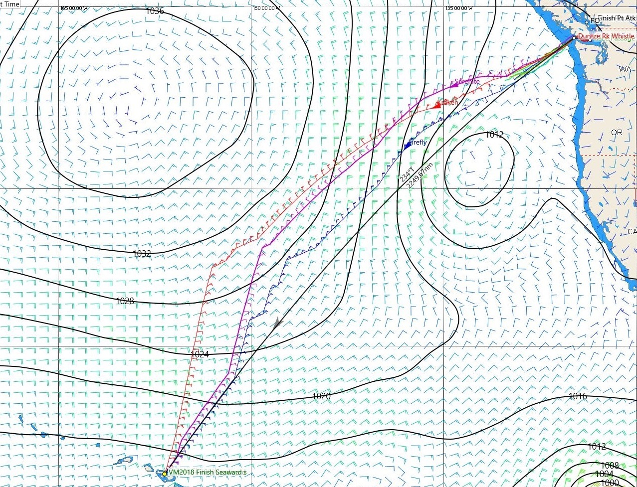
The North Pacific High is established and centered at about 43N 155W. It’s strong – about 1036mb – which is good, and about 600-800nm in diameter. There is a Low developing about 500nm West of Vancouver Island. A squeeze zone should develop between the High and the Low. Interesting!

Tue Jul 3, 0800PDT
The High is forecast to drift West while the Low is forecast to move SE and should be affecting the fleet from about Tuesday evening (tonight) through to Thursday morning. Most boats should see sustained wind speeds in the 15-25 knot range, while some may see up to 30 knots, bordering on gale force. Wind angles will change as the Low crosses the track, leading to a flurry of sail changes, and once settled the angles should be behind the beam and very favorable for fast sailing. Fast!
The fleet is currently sailing very close to the rhumb line, the shortest route to Hawaii. Shortest, but not necessarily the fastest. The High is likely to move farther West than usual, and combined with the Low it will be very attractive for the fleet to sail West of the rhumb line. Risky!

Wed Jul 4, 1600PDT
This is not the textbook route to Hawaii! The risk of being West of the rhumb line is getting swallowed up into the middle of the High if/when it comes back to its usual position. There is little to no wind in the middle of a high. On the other hand, trying to go East of the rhumbline means beating into the Low and possible light and variable winds when it dissipates. So the navigators will be thinking this routing decision out carefully. And there is always the possibility, nay, probability, that the actual weather will be different from the expected weather. A conservative strategy might be to sail on the favorable side of the low, stay as close to the rhumb line as practical, sail less distance, stay in the squeeze breeze, and take less risk of getting becalmed. Sounds easy!
Beyond the next few days and the passage of the Low, the trade winds ahead are looking good. Off to the Southeast, there is some tropical system activity to keep an eye on, with TS Emilia reportedly dissipated and TS/Hurricane Fabio strengthening and forecast to dissipate before affecting the Vic-Maui fleet’s probable track to Hawaii. One eye to weather!
Caveat: this article and the images are presented for informational purposes – they are not predictions of or advice to any boat regarding weather or routing!
Thank you to our featured sponsor:

We create professional websites. Our client’s sites are stunningly designed, highly functional and fully maintained using our web content management system, Vortex CMS.
We can quickly develop company profile websites; ecommerce sites with real-time payment and shipping integration; subscription-based sites; music and video rich sites; complex dynamic sites; interactive sites; custom databases and scripts; corporate identity and custom designed print media.
If you’re looking for a company that will understand what you want and deliver it quickly, we are the right company for you.
Website: http://www.eggbeater.ca
Featured Sponsor

Shackles & Cotterpins
Featured Yacht Profile
New Haven (2022)
 Type: Baltic
Skipper: Tim Slater
Port: Vancouver, BC
Blog: 1 articles posted
New Haven. A Baltic 38DB designed by naval architect Doug Peterson, is a racer/cruiser that was built for speed and comfort in high seas. Earlier in his life skipper Tim Slater (who is now supported by partner Erin Moore for this adventure) sailed the Pacific Ocean for three years on a cruising boat and is looking forward to doing this part of that cruise in a racing environment. He is the Vice Commodore at the False Creek Yacht Club and is their second entry alongside Elan, skippered by Paul McGarvey. Tim’s crew is a mixture of life experienced people of all ages, who have discovered a passion for sailing this boat and who are looking forward to participating in this endeavour that is the perfect conflation of racing and adventure.
PS: BBQ will stay on the rails, meals will be cooked and we’ll be taking showers….Defectors are welcome.