The Weather Eye, July 6 – One Third Down, Two Thirds to Go; Baby Bear's Porridge
by David Sutcliffe, July 6th, 2018
Let’s review. So far, the Vic-Maui fleet has:
- Beat into a stiff Westerly to exit the Strait of Juan de Fuca
- Turned left at Cape Flattery
- Sailed a fast reach in Westerlies of the North Pacific High
- Navigated through a lighter air transition zone associated with an approaching Low
- Set new boat speed records in the strong breeze and big seas of the gale force squeeze zone between the Low & High
- Emerged from the Low into Northwesterly breeze on the right / East shoulder of the High
- Seen the barometer oscillate Up-Down-Up like … a ride at the amusement park
Not bad for the first five days and about eight hundred miles of a 2,308 mile ocean race. One third down, two thirds to go!
So, it’s now 0600 PDT on Friday morning, July 6. Most boats have finished the first third of their race. What’s next in weather and routing?

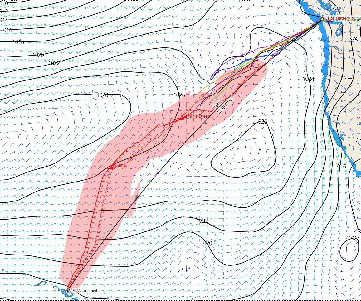
Fri Jul 6, 0600 PDT
The middle third (the next several days):
- The Low is now mostly out of the Vic-Maui picture
- The North Pacific High will be the dominant weather feature for the middle third of the race
- But … with the Low last seen leaving town headed North, the High is predicted to expand with a fat Eastward bulge, forming a large plateau that is likely to have very light winds
- Pinched between a Low to the North, and the remnants of TS Fabio to the South, the fat Eastward plateau of the High may temporarily form a second “East peak” – a secondary High with its own clockwise flow
- If this happens, there may be a saddle between these two peaks with opposing winds, causing poorly organized flows with light and variable conditions
- Boats will not want to sail on the plateau, in the saddle, or beat into the wind on the West side of the East peak. Essentially these are “no go” zones!
- Secondary High or not, boats will likely look for the line with the best wind speed to contour around the East side of the main/West peak
- One approach would be to use barometric pressure as a guide to climb onto and contour around the main/West peak. If the barometric pressure drops, turn right a little and sail a hotter angle. If the pressure rises, turn left a little and sail a lower angle.
- To do this successfully, the predicted/observed/achieved barometric pressure needs to be just right, like Baby Bear’s Porridge. Woe betide the navigator who serves up the wrong porridge!

Mon Jul 9, 1600 PDT (showing possible tracks for Joy Ride and Geminis Dream)
The final third (looking well ahead):
- Eventually, boats will need to gybe away from the High, and sail on Port gybe to angle across the Trade Winds to get to Maui
- The first big question (to mark the end of the middle third and the start of the final third of the race) will be when and where to gybe?
- Each boat will consider three main factors:
- the trend for the boat’s heading to be “lifted” away from pointing at Maui as the wind curves around the High
- the actual/predicted angle and strength of the Trade Winds, which can be anywhere from almost North to Northeast to East, and a typical range of ten to twenty-plus knots
- the performance characteristics of that particular boat; picking the best available wind angle and speed to sail in the sweet spot for that particular boat for the final third – something like seven hundred to nine hundred miles mostly on one gybe!
One eye on the weather!
Caveat: this article and images are presented for informational purposes – they are not predictions of or advice to any boat regarding weather or routing!
Featured Sponsor

Shackles & Cotterpins
Featured Yacht Profile
Phoenix (2022)
 Type: Xp 44
Skipper: Gordon Wylie
Port: Vancouver, BC Canada
Blog: 1 articles posted
Vic-Maui Welcomes Phoenix
Gordon Wylie's XP-44, Phoenix, is the 4th boat to register super-early for the 2022 Vic-Maui; he and his crew will put their offshore racing experience to the test in his new boat. Previously, Gordon raced his Express 37, Selkie, in the 2019 Oregon (now Pacific NW) Offshore.