The North Pacific High
by Guy Walters, July 12th, 2012
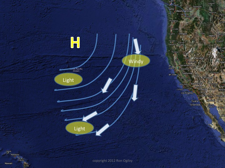
I am not the weather guru and won’t pretend to be. Rich offers his perspective of the present situation in his latest post. Without resorting to other sources and relying solely on the wind overlay on Yellowbrick, I suggest the following. The winds appear to be stronger to the east of the general track of the competitors, who are sailing in a south-westerly direction. The small colored triangles on the chart represent wind direction and velocity. It can be seen that the marks to the east of the boats represent more or less northerly winds on the order of 20 knots while the marks to the south and west represent winds of about 12 knots or less. Importantly, there is an area in the vicinity of 36°N 137°W where the wind velocities are below 5 knots and the directions are not advantageous. That area represents the centre of the North Pacific High, an area the competitors want to stay well clear of. The more westerly boats, such as Turicum, Ballymack and Red Sheilla, on their present courses, are skirting close to the centre of the high.
Nothing will happen if they sail into the centre of the high – literally nothing as they will run out of wind and stop sailing for a day or so. However, these boats have at least as much information as we do and will be aware of the “hole” and hopefully will take precautions to avoid it by altering course to the south in order to get around the bottom of the low wind region.
Featured Sponsor
Shackles & Cotterpins
Featured Yacht Profile
Flow (2022)
 Type: Dehler 36 SQ
Skipper: Stuart Horak
Port: North Vancouver, BC, Canada
Blog: 1 articles posted
Vic-Maui Welcomes Flow
Stuart Horak's Flow is back and is our tenth entry for the 2022 Vic-Maui!