The Weather Eye, July 2 - An Ocean Weather Primer for Vic-Maui Fans
by David Sutcliffe, July 2nd, 2018
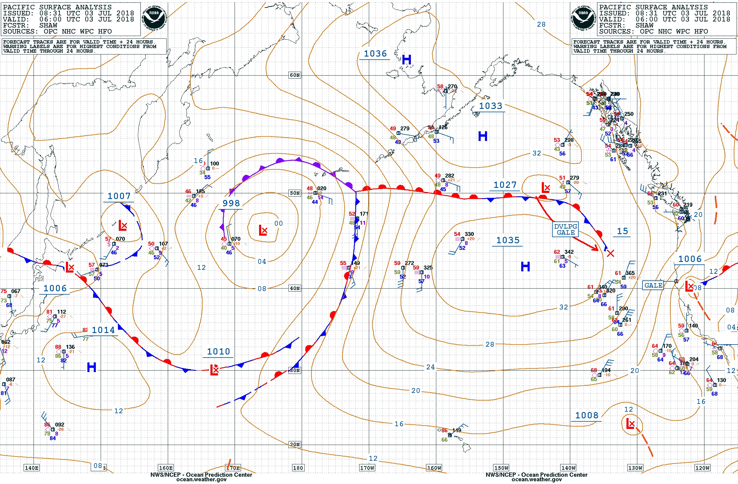
A quick primer on weather systems in the Northeast Pacific Ocean, between Cape Flattery and Hawaii.
1) The dominant summer pattern in the Northeast Pacific Ocean is usually the North Pacific High. Winds blow in a clockwise rotation around the High which is usually centered somewhere North of Hawaii and West of the US West Coast, say about 40N – 150W. The High usually spreads over a very large area of the ocean and wobbles around, expanding and contracting, usually without the center moving too far. Sunny and warm!

2) Temperate zone low pressure weather systems travel from West to East in the temperate zone which technically is between about 23 degrees and 66 degrees North latitude. Put another way, this zone is roughly between the Southern tip of Baja Mexico and the Bering Strait off Alaska. In summer, the lows usually travel in the higher or more Northern areas of this zone, and are usually deflected above the High. Winds blow in a counter clockwise direction around the lows. Cloudy and rainy!
3) In summer, the High usually deflects low pressure systems up into the Gulf of Alaska, keeping nice summer conditions over the West Coast of North America. When a high and a low system press against each other, there is usually a squeeze zone with stronger winds between the two systems. Breezy and lumpy!
4) Trade winds usually blow from the Northeast or East between about 30 degrees and 5 degrees North latitude. This band is roughly between the US-Mexico border and just North of the Equator. Trade winds usually blow steadily, but they are affected by El Nino and La Nina cycles, and there will usually be squalls. The bottom of the High and the North edge of the trade winds blend together over the ocean. Champagne sailing!
5) Tropical low pressure systems usually develop off the coast of Central America, and some strengthen to tropical storm or hurricane strength. As with other lows, the wind blows counter clockwise around these lows. These systems usually move Northwest to the open ocean area West of Baja Mexico before weakening and dissipating far from land. Sometimes they curve North and East to make landfall in Mexico, and occasionally they travel West towards or all the way to Hawaii. These systems can affect the trade winds. Pay attention!
So it’s all very simple, or maybe not! A dozen mentions of "usually". Now, imagine being the navigator onboard an ocean racing boat, queasy and sleep-deprived, peering at a laptop screen below-deck at oh-dark-hundred (two a.m. local time) while the boat rolls, pitches and heaves. Your information is limited to weather forecasts and observations that can be obtained over a very low-bandwidth and sometimes expensive communications link using either marine radio or satellite systems. Nothing is certain, and reality often doesn’t look like the textbook said it would. The rest of the crew each have their own opinions, and then there are the armchair quarterbacks back home on dry land, cozy and warm and dry, sipping their coffees. Which way to go? What to worry about? How best to get to Hawaii safely and fast?
One eye to weather!
Thank you to our featured sponsor:
![]()
Built in 1901 and substantially remodeled to meet Best Western standards, the Pioneer Inn in Lahaina, Maui, captures the ambiance of the whaling days and the plantation era, with architecture that evokes the tranquil lifestyle of turn of the century Lahaina while offering all the comforts and convenience of a modern hotel.
Phone: (808) 661-3636
Website: http://www.pioneerinnmaui.com/
Featured Sponsor
Shackles & Cotterpins
Featured Yacht Profile
Phoenix (2022)
 Type: Xp 44
Skipper: Gordon Wylie
Port: Vancouver, BC Canada
Blog: 1 articles posted
Vic-Maui Welcomes Phoenix
Gordon Wylie's XP-44, Phoenix, is the 4th boat to register super-early for the 2022 Vic-Maui; he and his crew will put their offshore racing experience to the test in his new boat. Previously, Gordon raced his Express 37, Selkie, in the 2019 Oregon (now Pacific NW) Offshore.